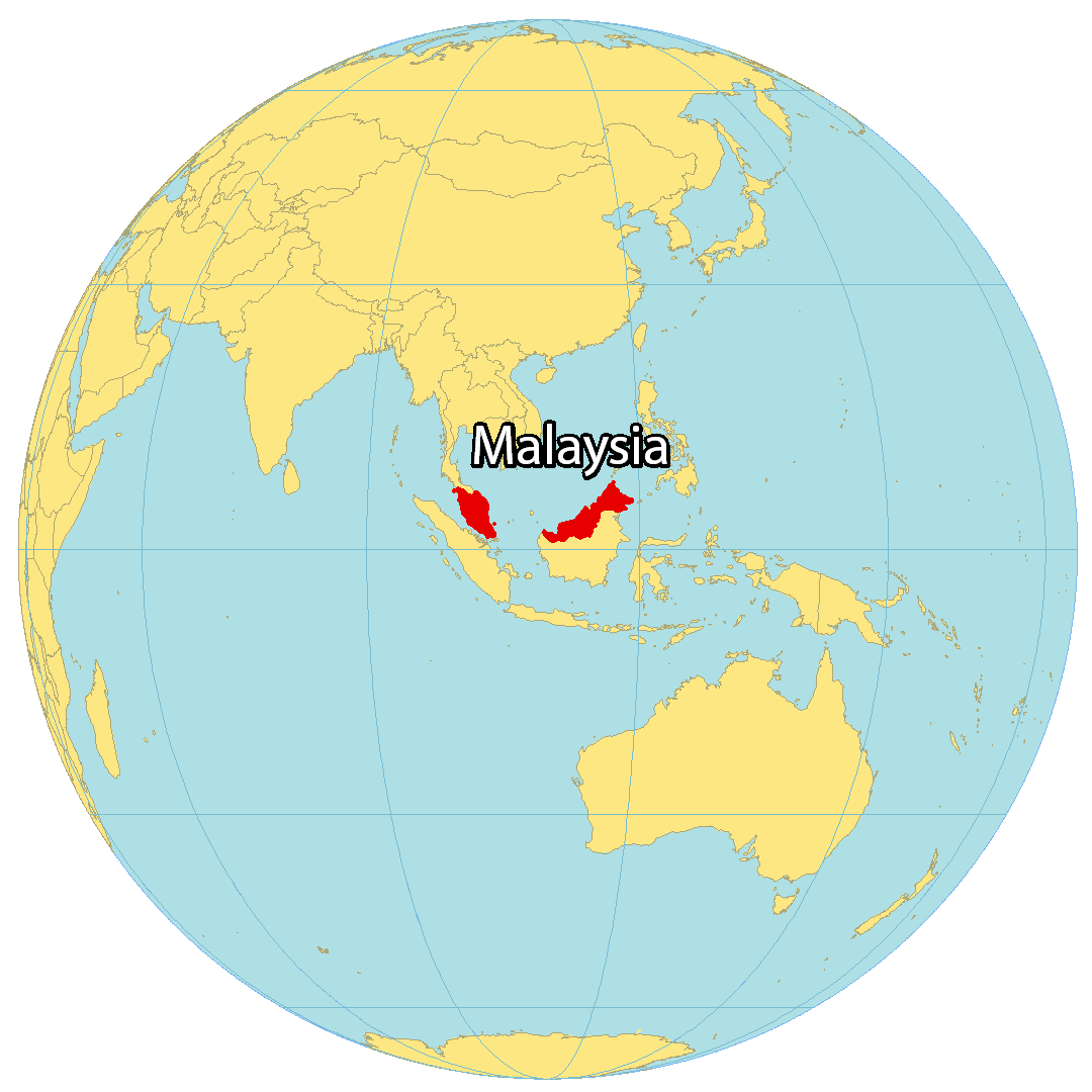
Planning a trip or simply curious about global geography? Discover exactly where Malaysia is located on the world map, a key nation in Southeast Asia. This comprehensive guide helps U.S. searchers understand its geographical position, neighboring countries, and maritime borders. Learn how Malaysia's unique placement influences its diverse climate, vibrant cultures, and incredible natural attractions, making it a compelling destination for American travelers. We explain why its position matters for travel logistics, including flight routes from the U.S. and considerations for planning your journey. Use this information to confidently identify major cities like Kuala Lumpur, Penang, and Kota Kinabalu, and to pinpoint stunning natural wonders such as the Perhentian Islands or Mount Kinabalu. Understand how to compare travel options, book accommodations, and find local services, all informed by a clear understanding of Malaysia's place on the map. This resource is essential for anyone considering a visit to this captivating country in 2026.
- What are the visa requirements for US citizens visiting Malaysia? - U.S. citizens typically do not need a visa for tourist stays in Malaysia lasting up to 90 days. You need a valid passport with at least six months validity remaining beyond your intended departure date. Always verify the latest requirements with the Malaysian Embassy or Consulate before traveling, as rules can change.
- What is the best time of year to visit Malaysia? - The best time to visit Malaysia varies by region. For Peninsular Malaysia's west coast (e.g., Kuala Lumpur, Penang), December to February is ideal. For the east coast (e.g., Perhentian Islands), June to August is best. East Malaysia (Borneo) is generally good from March to October, avoiding the monsoon season for specific areas.
- What languages are spoken in Malaysia? - The official language of Malaysia is Bahasa Malaysia (Malay). English is widely spoken, especially in urban areas and tourist destinations, making it easy for U.S. travelers to communicate. Mandarin Chinese and Tamil are also commonly spoken among specific communities, reflecting Malaysia's diverse population.
- Can I use US dollars in Malaysia? - No, the official currency is the Malaysian Ringgit (MYR). While some major hotels or tourist shops might accept U.S. dollars in specific instances, it is not common practice. Always exchange your U.S. dollars for Ringgit or withdraw local currency from ATMs for transactions, ensuring better rates and wider acceptance.
- What are popular Malaysian foods to try? - Malaysian cuisine is a delicious blend of Malay, Chinese, and Indian flavors. Must-try dishes include Nasi Lemak, the national dish; Laksa, a spicy noodle soup; Satay, grilled skewers with peanut sauce; and Roti Canai, a flaky flatbread. Food stalls and hawker centers offer authentic and affordable culinary experiences.
- How can I get around Malaysia? - Within cities like Kuala Lumpur, ride-sharing apps, taxis, and public transport (LRT, MRT, Monorail) are efficient. For inter-city travel on Peninsular Malaysia, buses and trains are popular. To travel between Peninsular Malaysia and Borneo, flying is necessary. Renting a car is an option, but driving can be challenging for those unfamiliar with local roads.
- Are there direct flights from the US to Malaysia? - Currently, there are no direct commercial flights from the United States to Malaysia. Travelers typically fly with one or two layovers through major international hubs in Asia (e.g., Tokyo, Seoul), Europe (e.g., London, Amsterdam), or the Middle East (e.g., Doha, Dubai). Plan for a travel duration of 18-28 hours.
What are Malaysia's main islands?
Malaysia is composed of a peninsula and part of Borneo, not a single main island. Its most famous islands for tourism include Langkawi, the Perhentian Islands, and Tioman Island off Peninsular Malaysia. In East Malaysia, islands around Sabah like Sipadan are renowned for diving. These island destinations offer beautiful beaches and rich marine life for visitors.
How far is Malaysia from the US?
Malaysia is located a significant distance from the U.S., making for a long journey. For example, Kuala Lumpur is approximately 9,500 to 10,000 miles from major U.S. cities like Los Angeles or New York. Flights typically involve one or two layovers in other major international hubs, with total travel times often ranging from 18 to 28 hours, depending on the route.
What currency is used in Malaysia?
The official currency used in Malaysia is the Malaysian Ringgit (MYR). It is typically denoted with the symbol RM. U.S. travelers should exchange their U.S. dollars for Ringgit upon arrival or withdraw local currency from ATMs. While major credit cards are widely accepted in urban areas, having local currency is essential for smaller vendors and rural regions.
Is Malaysia safe for tourists?
Malaysia is generally considered a safe country for tourists, including those from the U.S. However, like any travel destination, it is important to exercise standard precautions. Petty crime, such as pickpocketing, can occur in crowded tourist areas. Travelers should remain aware of their surroundings, protect valuables, and use reputable transportation services. Staying informed on local news is always a good practice.
What are major airports in Malaysia?
The primary international gateway to Malaysia is Kuala Lumpur International Airport (KLIA), located south of the capital. It is a major hub for flights from around the world. Other important international airports include Penang International Airport (PEN) and Kota Kinabalu International Airport (KKIA) in Sabah, East Malaysia. These airports connect travelers to various domestic and international destinations.
Malaysia on the World Map Your Essential GuideMany Americans often wonder about the precise location of Malaysia on the world map. This Southeast Asian nation holds a unique geographical position, influencing its rich biodiversity, diverse cultures, and its role in global trade and tourism. Understanding where Malaysia sits helps U.S. travelers plan trips more effectively and appreciate its regional context. This guide provides clear answers, helping you locate Malaysia with ease and explore its significance for your next adventure.
For those considering a visit in 2026 or simply expanding their geographical knowledge, recognizing Malaysia's placement is the first step. It is a country of two main parts, separated by the South China Sea, each offering distinct experiences. Knowing its neighbors and maritime zones offers crucial context for everything from political understanding to travel itineraries. This article helps you visualize Malaysia's home on the global stage, providing useful information for travel, education, or general interest.
As an informed U.S. traveler, gaining a clear picture of Malaysia's geography allows you to make better decisions. Whether you are looking for beach getaways, jungle treks, or bustling city explorations, a solid understanding of the map informs your choices. This content is crafted to make that understanding straightforward and helpful, laying the groundwork for exciting discoveries about this fascinating country.
Where is Malaysia Located on the World Map Exactly
Malaysia is situated in Southeast Asia, north of the Equator. Its unique geography splits the country into two primary regions: Peninsular Malaysia and East Malaysia. Peninsular Malaysia, often called West Malaysia, occupies the southern part of the Malay Peninsula. It shares a land border with Thailand to the north and is connected by a causeway and a bridge to Singapore in the south. To its east across the South China Sea lies East Malaysia.
East Malaysia, also known as Malaysian Borneo, is located on the northern part of the island of Borneo. Here, it shares land borders with Brunei and Indonesia. The South China Sea separates these two distinct parts of Malaysia. This maritime divide is crucial, not only geographically but also in terms of cultural and environmental differences. Understanding this dual nature is key to truly grasping Malaysia's position on the world stage.
Malaysia's coastal areas face important waterways such as the Strait of Malacca, a major shipping lane between the Indian Ocean and the Pacific Ocean. Its strategic location has historically made it a hub for trade and cultural exchange. For U.S. citizens, identifying these features on a world map provides important context for international relations, travel routes, and even global economic patterns related to shipping.
Understanding Southeast Asia's Geography
Southeast Asia is a large region known for its archipelagos and peninsulas. Malaysia is a central part of this vibrant area, nestled among other prominent nations. To the west of Peninsular Malaysia lies the Andaman Sea, while to the east is the South China Sea. These waters are significant for global trade and contain rich marine biodiversity.
The region's geography also shapes its climate, which is typically tropical with consistent heat and humidity. Monsoons influence rainfall patterns throughout the year. For U.S. visitors, understanding this geographical setting means being prepared for specific weather conditions, which can impact travel plans and activities. Always check the weather for your specific Malaysian destination.
Malaysia's position within Southeast Asia also means it is relatively close to other popular tourist destinations like Vietnam, Cambodia, and the Philippines. This proximity can be a consideration for U.S. travelers planning multi-country trips, making Malaysia an excellent starting point or a connecting destination within a larger regional itinerary.
Key Neighboring Countries and Maritime Borders
Malaysia shares its longest land border with Indonesia on the island of Borneo. This border stretches through dense jungle terrain. To the north of Peninsular Malaysia, Thailand forms another significant land border. These shared landmasses create complex ecosystems and cultural overlaps that are interesting to explore.
Across the narrow Johor Strait, Singapore lies just south of Peninsular Malaysia, connected by well-traveled bridges. Further north on Borneo, the small nation of Brunei is entirely surrounded by Malaysian territory and the South China Sea. These close relationships mean frequent cross-border movements and economic ties.
Maritime borders are also important for Malaysia. Its waters touch those of Vietnam, the Philippines, and China in the South China Sea. These shared waters are vital for fishing, oil and gas exploration, and international shipping. For U.S. citizens tracking global events, understanding these geographical relationships can offer clearer insights into regional dynamics.
Why Does Malaysia's Position Matter for U.S. Travelers
Malaysia's location holds practical implications for U.S. travelers planning a visit. The distance and geographical placement directly influence flight times, available routes, and overall travel logistics. Knowing where Malaysia is helps you mentally prepare for the journey and optimize your travel schedule, ensuring a smoother and more enjoyable experience.
Beyond travel practicalities, Malaysia's position also dictates the kind of climate you will encounter and the natural landscapes you will see. Situated near the Equator, it boasts a tropical climate year-round, which is very different from much of the U.S. This impacts what you pack, when you choose to visit, and the types of activities you can enjoy, from beach relaxation to jungle exploration.
Furthermore, Malaysia's location as a crossroads of cultures in Southeast Asia contributes to its unique identity. Malay, Chinese, and Indian influences are prominent, reflected in its food, festivals, and architecture. For American visitors, this blend offers an enriching cultural experience that is directly tied to its historical and geographical context. Discovering this diversity is a major draw.
Impact on Travel Time and Routes from the USA
Traveling from the United States to Malaysia involves a significant journey due to the vast distance. Direct flights are not common from most U.S. cities, meaning travelers typically connect through major hubs in Asia, Europe, or the Middle East. Common layover cities include Tokyo, Seoul, Hong Kong, Doha, Dubai, or Istanbul.
A typical flight from the West Coast of the U.S. (e.g., Los Angeles) to Kuala Lumpur can take around 18-24 hours, including layovers. From the East Coast (e.g., New York), the total travel time can extend to 20-28 hours. It is important to factor in these long travel durations and consider potential jet lag when planning your itinerary.
To find the best routes and deals, U.S. travelers should use online flight comparison tools and check various airlines. Booking in advance usually provides better prices. Understanding Malaysia's location on the world map helps in visualizing these routes and estimating total travel time, which is essential for managing expectations and preparing for your journey.
Climate Zones and Seasonal Considerations
Because Malaysia sits close to the Equator, it experiences a tropical rainforest climate. This means consistent high temperatures, high humidity, and abundant rainfall throughout the year, with less distinct seasons compared to temperate regions. Daily temperatures generally hover around 80-90 degrees Fahrenheit (27-32 degrees Celsius).
While there are no true seasons, Malaysia does experience monsoon periods that bring heavier rainfall. The Northeast Monsoon (roughly November to March) impacts Peninsular Malaysia's east coast and East Malaysia. The Southwest Monsoon (roughly May to September) affects Peninsular Malaysia's west coast. Travelers should research the specific monsoon patterns for their planned destination within Malaysia.
For U.S. travelers, this tropical climate dictates packing light, breathable clothing, and preparing for humidity. Understanding these climate zones helps in choosing the best time to visit certain regions to avoid peak rainy seasons, especially if outdoor activities are a priority. Always check the forecast for 2026 before you depart.
How to Use a Malaysia World Map for Travel Planning
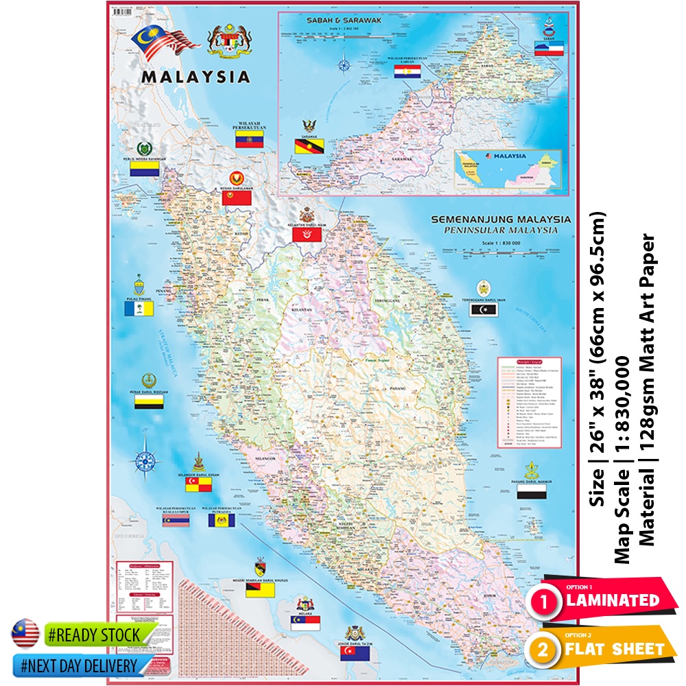
Using a detailed Malaysia world map is invaluable for effective travel planning, especially for U.S. visitors who might be unfamiliar with the region. A good map helps you visualize distances, identify key points of interest, and plan your itinerary logically. It serves as your primary tool for navigating the country before and during your trip.
Start by orienting yourself. Locate Peninsular Malaysia and East Malaysia, understanding the scale between them. This immediately clarifies why internal flights are often necessary to travel between the two parts. A map helps you see how major cities, natural parks, and coastal areas are positioned relative to each other, allowing for efficient route planning.
Additionally, a map assists in understanding local transportation networks. You can see where major highways are located, identify ferry routes to islands, or pinpoint airport locations. This visual aid is crucial for determining how much time to allocate for travel between destinations and for making informed decisions about ground or air transport. Utilize online mapping services for current conditions.
Identifying Major Cities and Tourist Destinations
When you look at Malaysia on a map, you will quickly spot its most prominent cities and attractions. In Peninsular Malaysia, Kuala Lumpur stands out as the capital and a major international gateway. Other key cities include George Town in Penang, known for its heritage, and Malacca City, another historical gem. These are often the first points of interest for U.S. travelers.
For those seeking island escapes, the map clearly shows destinations like Langkawi, the Perhentian Islands, and Tioman Island along the coasts of Peninsular Malaysia. In East Malaysia, Kota Kinabalu in Sabah and Kuching in Sarawak are the main cities. Mount Kinabalu, Southeast Asia's highest peak, is also clearly visible in Sabah.
By marking these spots on your map, you can begin to create a coherent travel route. Consider clustering destinations that are geographically close to minimize travel time. This visual approach helps U.S. tourists prioritize what they want to see and ensures they do not miss out on key attractions that align with their interests in 2026.
Planning Transportation and Logistics
Once you have identified your desired destinations using the Malaysia world map, the next step is to plan your transportation and logistics. For travel between Peninsular Malaysia and East Malaysia, flying is the most practical option. Major airports like Kuala Lumpur International Airport (KLIA) and Kota Kinabalu International Airport (KKIA) serve as crucial hubs.
Within Peninsular Malaysia, an extensive road network makes travel by bus or rental car feasible. Trains also connect some major cities. For island hopping, ferries are the primary mode of transport. In East Malaysia, internal flights are often necessary to cover long distances between cities and national parks, alongside local bus services.
Using a map to plot these routes helps you estimate travel times and costs. For example, knowing the distance between Kuala Lumpur and Penang helps you decide if a flight, train, or bus is best. For U.S. travelers, understanding these logistics well in advance can prevent unforeseen delays and ensure a smooth journey throughout Malaysia.
What are Key Regions to Explore in Malaysia
Malaysia offers a wide array of regions, each with its own character and attractions, making it a diverse destination for U.S. travelers. Understanding these regions on a map helps you tailor your trip to your specific interests, whether you are drawn to bustling city life, ancient rainforests, or pristine beaches. The country's dual geography ensures a variety of experiences.
Peninsular Malaysia, the western part, is more developed and densely populated. It features vibrant cities, historical sites, and popular beach resorts. East Malaysia, on the island of Borneo, offers a wilder, more adventurous experience with vast rainforests, unique wildlife, and indigenous cultures. Both parts provide compelling reasons to visit.
When planning your trip for 2026, consider what kind of adventure you are seeking. Do you prefer cultural immersion and urban exploration, or are you hoping for nature encounters and outdoor activities? A quick glance at the Malaysia world map can help you visualize these distinct regions and choose the ones that best fit your travel style.
West Malaysia Peninsula Highlights
Peninsular Malaysia is home to the capital, Kuala Lumpur, a modern metropolis known for its Petronas Twin Towers, diverse shopping, and a blend of Malay, Chinese, and Indian cultures. It is an excellent starting point for most U.S. travelers, offering world-class amenities and direct connections to other parts of the country.
Further north, Penang Island, with its capital George Town, is a UNESCO World Heritage site famous for its street art, colonial architecture, and incredible food scene. It offers a captivating mix of history and gastronomy. The nearby island of Langkawi provides stunning beaches, duty-free shopping, and lush rainforests for relaxation and adventure.
On the east coast of the peninsula, islands like the Perhentians and Tioman are renowned for their clear waters, coral reefs, and fantastic snorkeling and diving opportunities. These spots offer a tranquil escape from city life and are perfect for beach lovers looking for natural beauty. Consider visiting during the dry season for the best experience.
East Malaysia Borneo Adventures
East Malaysia, on the island of Borneo, offers a stark contrast with its ancient rainforests, unique wildlife, and rugged landscapes. Sabah, one of the two states, is famous for Mount Kinabalu, a popular trekking destination. It is also home to orangutan rehabilitation centers and diverse marine life around islands like Sipadan, a world-class diving spot.
Sarawak, the other state in East Malaysia, is known for its vast national parks, indigenous longhouses, and unique cultural experiences. Visitors can explore Mulu Caves National Park, a UNESCO World Heritage site with massive cave systems, or encounter proboscis monkeys and other Borneo wildlife along river cruises.
For U.S. travelers seeking authentic nature and adventure, East Malaysia is an unparalleled choice. It provides opportunities for ethical wildlife encounters, cultural immersion with local tribes, and challenging outdoor activities. A trip here allows you to experience a very different side of Malaysia compared to the peninsula.
Conclusion Navigating Malaysia's Global Spot for U.S. Travelers
Understanding Malaysia's place on the world map is more than just a geographical exercise; it is a crucial step for U.S. travelers planning an unforgettable trip. By pinpointing its location in Southeast Asia, its distinct peninsular and Borneo regions, and its diverse neighbors, you gain valuable context for travel planning, cultural understanding, and logistical considerations. This knowledge empowers you to make informed decisions about your itinerary, from choosing destinations to booking flights and understanding local climate patterns.
As you plan your adventures for 2026, remember that Malaysia offers a vibrant blend of experiences, from the modern cityscape of Kuala Lumpur to the ancient rainforests of Borneo. Using a world map as your guide helps you connect the dots, visualize distances, and select the regions that best align with your interests, whether they involve cultural immersion, beach relaxation, or thrilling wildlife encounters. It is an essential tool for unlocking the full potential of your Malaysian journey.
So, take the time to explore Malaysia on the world map. See how its position makes it a melting pot of cultures and a biodiversity hotspot. Let this geographical insight be the foundation for a well-planned and enriching travel experience. Begin your research today to discover the unique wonders that await U.S. visitors in this incredible Southeast Asian nation.
Malaysia location on world map, Malaysia geographic features, Malaysia travel map U.S. tourists, planning a trip to Malaysia, best places in Malaysia map, Malaysia cultural insights




Singapore Malaysia Maps Location Tourist Spots Routes 2026 Malaysia And Singapore In World Map . Malaysia Map Malaysia . Malaysia On The World Map Political Map Of Malaysia ILVRR Malaysia World Map . Malaysia Maps Facts World Atlas My 02 . Malaysia Trip 2026 By Ingmarson Penzhorn Polarsteps


Malaysia Maps Facts World Atlas My 01 . World Map Showing Malaysia World Data Locator Map Malaysia . Malaysia Median Age 1960 2026 True Size On The Map Malaysia . Malaysia History Flag Map Population Language Religion Facts World Data Locator Map Malaysia . Area Map Of Malaysia And Surrounding Countries Malaysia Map


274 World Map 2026 Stock Photos Free Royalty Free Stock Photos From Wroclaw Poland March Close Up Strait Malacca Political World Map Showing Singapore Kuala Lumpur Malaysia One 446559790 . Where Is Malaysia Located On The World Map JFFA Malaysia Map . Malaysia Online E Visa Application Malaysia Map Cities 0 . IKON Concert Malaysia 2026 FOUREVER World Tour IKON FOUREVER WORLD TOUR 2026 Malaysia Ticket Price Seat Map.webp. Malaysia Maps Free Printable Maps Of Malaysia Mappr Malaysia Capital Location Map Black And White With Raster


Malaysia 2026 Miss World Untitled Design 18 . IKON Concert Malaysia 2026 FOUREVER World Tour IKON FOUREVER WORLD TOUR 2026. Physical Map Of Malaysia Malaysia Physical Map . Where Is Malaysia Located On The World Map JOXN States And Territories Of Malaysia Map . Malaysia Map HD Political Map Of Malaysia Malaysia States And Capital Map


Malaysia Tropical Monsoon Humid Britannica Malaysia Map Boundaries Cities Locator . 274 World Map 2026 Stock Photos Free Royalty Free Stock Photos From Wooden Blocks Displaying Year Positioned World Map Wooden Blocks Displaying Year Positioned World Map Showcasing 418434704 . Malaysia On World Map Royalty Free Vector VectorStock Pacific Centered World Map With Magnified Vector 37472019 . Malaysia On World Map Malaysia World . Malaysia Maps Map Political 1


2026 Malaysia Budget Logo Color . Where Is Malaysia Where Is Malaysia . Malaysia Political Map Political Map Of Malaysia MTIVY Malaysia States Map . World Map And Year 2026 Of The World Map With The Year 1000 F 1754974276 . Singapore Malaysia Maps Location Tourist Spots Routes 2026 Singapore Malaysia Thailand In World Map


Map Of Malaysia The Large Peninsular 26 X 38 66 X 96 5cm High. Malaysia In World Map Political Map Of Malaysia DXCF . Malaysia Map Maps Malaysia South Eastern Asia Asia Malaysia On World Map . World Map 2026 Defacto Borders Stock Photos Free Royalty Free Stock Future Planning Wooden Blocks Showing Map Asia Europe Concept 419099971 . UN Adopts New Map With Smaller US Bigger Africa FMT Ce8812db 01aa 4829 9efc Equal Earth AFP UN World Map